Glasgow Visitor Guide - Colin Baxter Glasgow Insight Pocket Guide

City of Glasgow


 Cathkin Braes Country Park

Glasgow - A Portrait Wee Book of Glasgow


Photographs of Cathkin Braes Country Park

 on the South Side of Glasgow


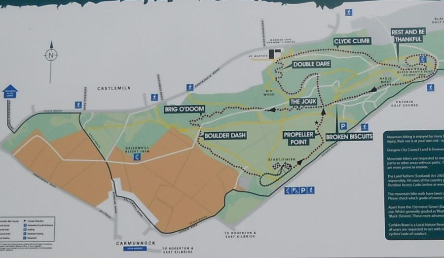
Map of Cathkin Braes Country Park

Map of Cathkin Braes Country Park

( Note: Click here or on map for large format copy )


The park is renowned for panoramic views over Glasgow,

 the Gleniffer Braes, Kilpatrick Hills and Campsie Fells.

Ben Lomond may also be seen.

The natural environment of the park

contains ancient woodlands, grasslands, heath and scrub.

 Abundant paths make the park ideal

for walking, picnics, recreation and environmental study.

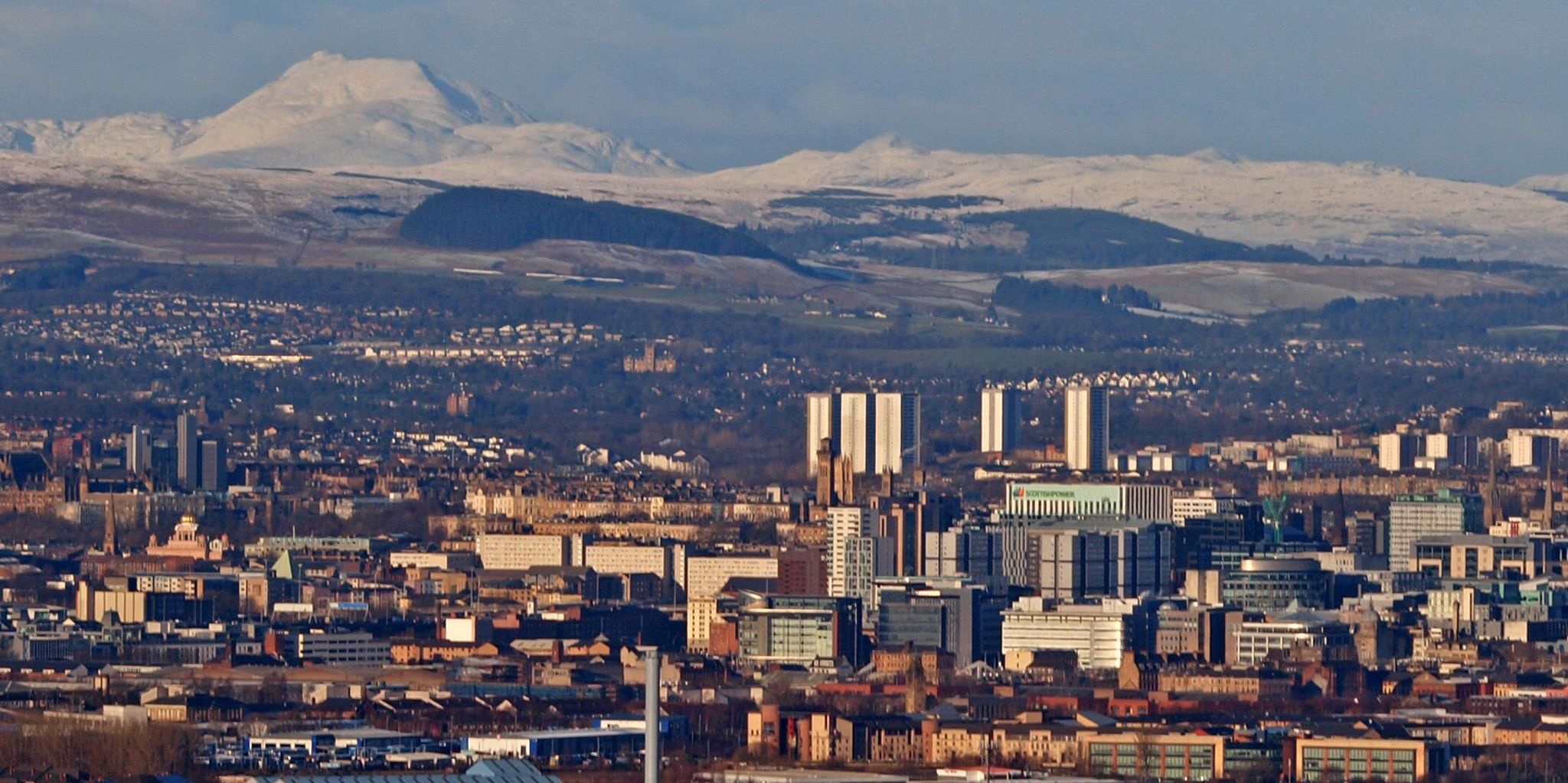
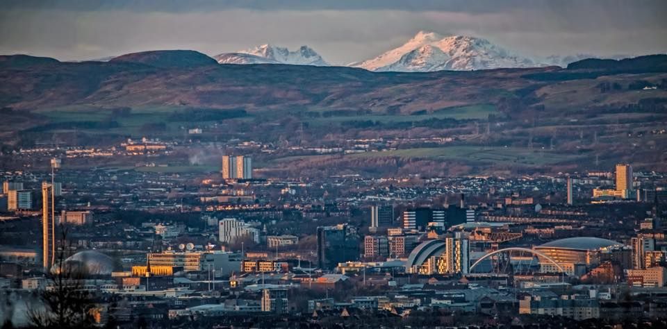
View of Glasgow and the Campsie Fells from the trig point in Cathkin Braes Country Park

Glasgow and the Campsie Fells

 from the trig point

 in Cathkin Braes Country Park

The Cathkin Braes have the highest point in Glasgow

 at a height of some 200 metres

Queen Mary's Seat near the high point

 is from where Mary Queen of Scots

 is reputed to have watched the Battle of Langside
.


Mountain Bike trail in Cathkin Braes Country Park

Mountain bike trail

 
in Cathkin Braes Country Park

The park has been selected as the venue

 for the 2014 Commonwealth Games mountain bike races.


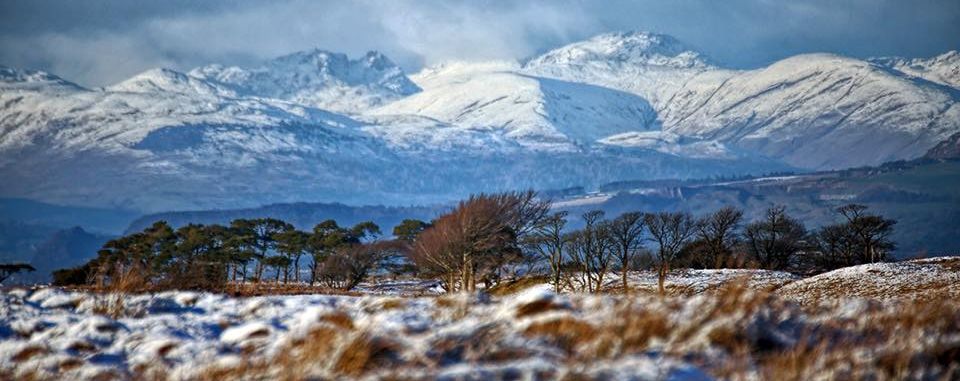
Dumgoyne and the Campsie Fells beyond Glasgow from Cathkin Braes Country Park

Dumgoyne and the Campsie Fells

beyond Glasgow

from Cathkin Braes Country Park


Woods in Cathkin Braes Country Park

Woods in Cathkin Braes Country Park


Mountain bike trail in Cathkin Braes Country Park

Mountain bike trail

 
in Cathkin Braes Country Park


Wind Turbine in Cathkin Braes Country Park

Wind Turbine

 in Cathkin Braes Country Park


Signpost in Cathkin Braes Country Park

Signpost

 in Cathkin Braes Country Park


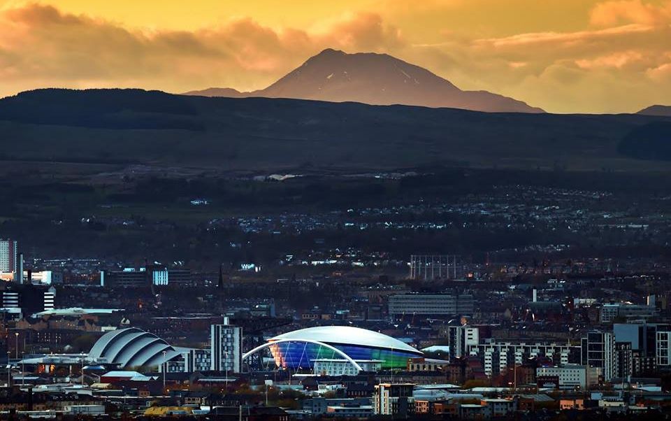
Ben Lomond and Glasgow from Cathkin Braes Country Park

Ben Lomond and Glasgow

from Cathkin Braes Country Park


Ben Lomond and Glasgow from Cathkin Braes Country Park

Ben Lomond and Glasgow

from Cathkin Braes Country Park


Ben Lomond and Glasgow from Cathkin Braes Country Park

Ben Lomond and Glasgow

from Cathkin Braes Country Park


Ben Lomond and Glasgow from Cathkin Braes Country Park

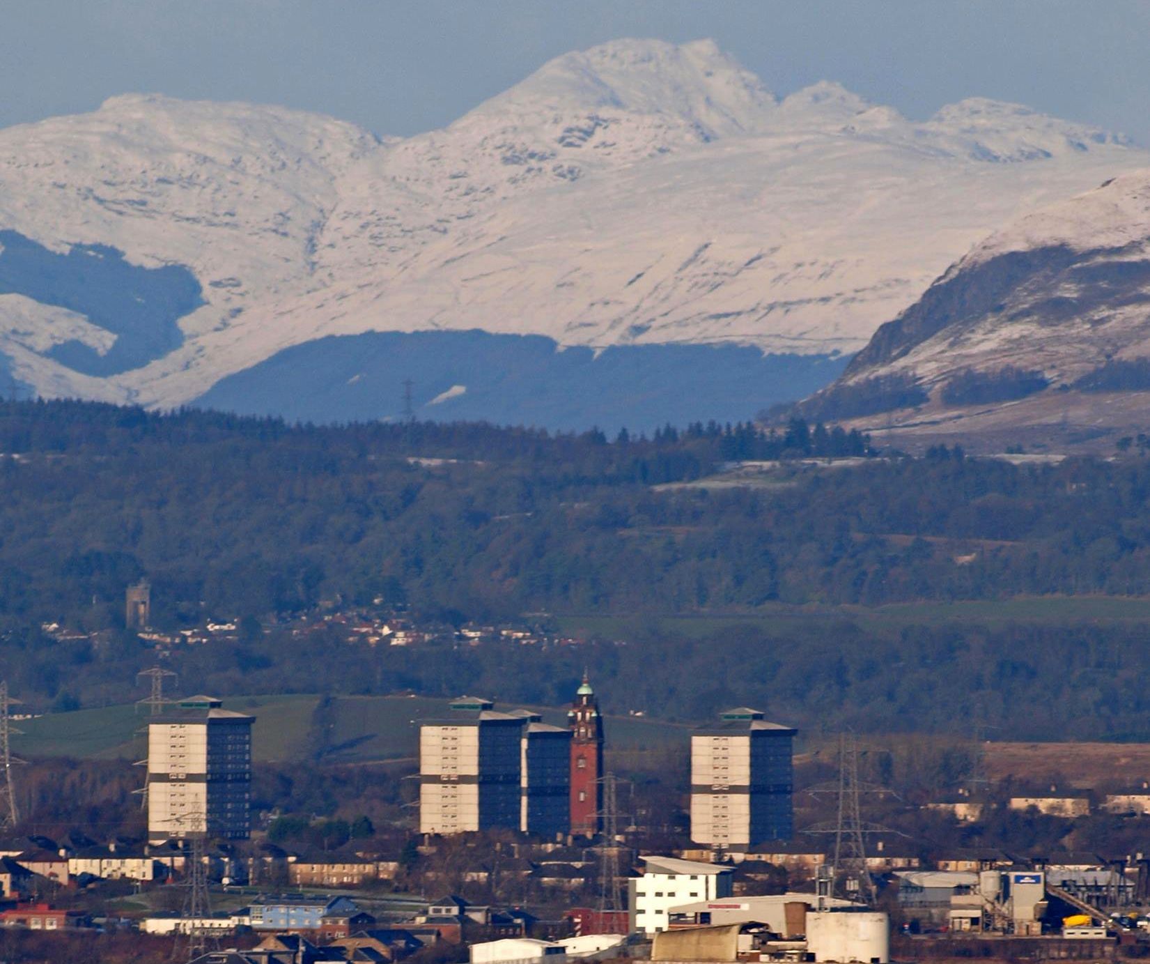
Cobbler ( Ben Arthur ) and Ben Lomond

above Glasgow

from Cathkin Braes Country Park


Arrochar Alps from Cathkin Braes Country Park

Arrochar Alps

from Cathkin Braes Country Park


Ben Lomond from Cathkin Braes Country Park

Ben Lomond

from Cathkin Braes Country Park


Church in Carmunnock Village adjacent to Cathkin Braes Country Park

Parish Church in Carmunnock Village

 adjacent to Cathkin Braes Country Park


Carmunnock Village

Kirk Road in Carmunnock Village


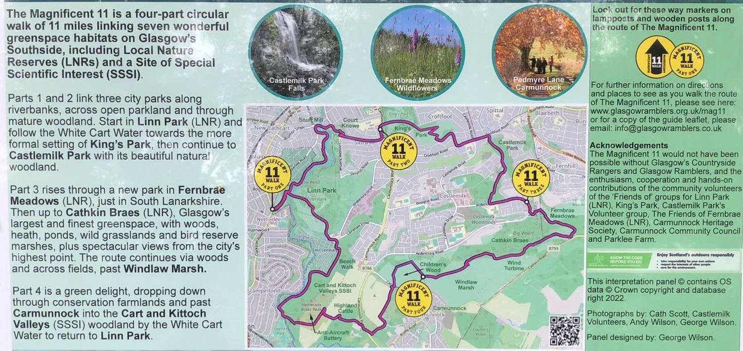
Magnificent 11 Route Map

Magnificent 11 Route Map


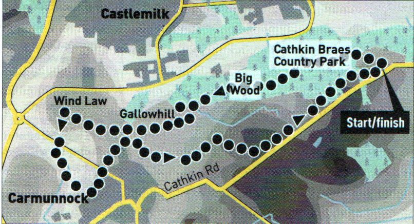
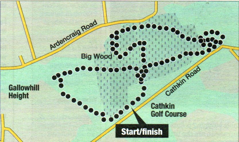
Route Map for Cathkin Braes Country Park

Route Map for Cathkin Braes Country Park


CATHKIN BRAES - ROUTE DESCRIPTION:

Location: Glasgow
Map: OS Land ranger 64
[GR 610579]
Distance: 4.5miles [7.5km]
Time: 2 hours
Terrain: paths, muddy in places


Forming part of the high ground surrounding Glasgow to the south, Cathkin Braes offers a spectacular panorama over the city with views from the peaks of Arran to the southern highlands.
At the eastern end of the braes’ rocky escarpment is Queen Mary’s Seat from where Mary Stuart is said to have watched the Battle of Langside in 1568.
The Braes form a country park easily approached from the large car park in Cathkin Road, at the park’s southern boundary, or from Castlemilk's Ardencraig Road. From the right end of the car park follow a path parallel to the road heading towards the aerial seen above Big Wood to the north. On the woodland edge following the track left for about 65 metres to a path on the right leading into the wood. Follow this to a larger path, continuing ahead and keeping left at any main divisions, until the aerial and its buildings come into sight.
Continue in the woodland, crossing over a burn to regain the main path and exit on to the grass and Queen Mary’s Seat beyond.
At 192m, the trig point at the aerial is the highest point in the city with great views and a backdrop of Ben Lomond, Stob Binnein, Ben More and Ben Ledi.
Descend a gully in the escarpment and veer left to a lower path. Keep left Where it divides and go through a wall gap.
Continue ahead, the right turn offers a loop path which you join later, to a further division. Go right, left heads straight into Big Wood, and continue along the crest to join the loop path. Ascend past a stone gatepost to the main path in Big Wood and follow it on past a path leading back left to the car park. Soon after crossing the burn, leave the woodland for the prepared path on the left, following it to a junction. Turn left towards the car park, then right on to a field path which leads to the top of Gallowhill. Descend the other side to cross Windlaw Road, now a pedestrian path from Carmunnock, and ascend a grassy path to Wind Law trig point (138m).
Return to the hill crest, then descend diagonally right to a gate in Carmunnock Road. Cross over on to a path between hedges, Pedmyre Lane, and follow this for 60 metres to the entrance to Carmunnock Copice Woodland, left. Follow the burn then ascend to skirt below houses to a gate on the village’s western edge. Cross Carmunnock Road and follow a grass path to a gap in the hedge.
Re-cross the tarmac path and ascend towards Gallowhill, veering right near the top to a grassy path heading to Carmunnock’s east end. Go through a hedge gap, then left above a marsh area to gain the main path leading to the carpark.


Cycle Route Map for Cathkin Braes Country Park

Cycle Route Map for Cathkin Braes Country Park


CATHKIN BRAES CYCLE ROUTE - ROUTE DESCRIPTION:

Location: Glasgow
Map: download from glasgow.gov.uk
Distance: 3.5 miles (5.5km)
Time: about 30 minutes for one lap
Terrain: hilly; blue/red-graded singletrack

Developed for the Glasgow 2014 Commonwealth Games this is a much-needed addition to mountain bike trails in the Central Belt.
It doesn’t pull its punches and the influence of world-class track designer Phil Saxena is evident throughout, particularly in the fast second half of the 3.5-mile route. Cathkin Braes hosted its first competition with the Scottish Cross Country Championship on the course designed as blue, with faster red (and some black) features. There is also a 750m warm-up green loop. For mere mortals, though, most of the technical features can be bypassed or ridden slowly with care.
Pedal out from the start past a wind turbine to the dramatic Propeller Point feature As its name suggests this will speed you into the waiting woods.
A large rocky drop follows before you whizz out to the head of Double Daxe — long bermed tracks with jumps.
Swinging east, Clyde Climb exerts the muscles to reach Rest and Be Thankful and superb views over the city. A woodland ridge,
to the left of a radio mast, leads across knobbly bedrock, Broken Biscuits.
Go through the tunnel for the serious boulder-studded Jouk. Now on velocity-inducing berms hold on to flash through the woods. The Brig o’ Doom and several sharp turns will also raise a grin.


Cathkin Braes Gallery  
Photo Gallery

<< Back :: Glasgow Parks :: Next >>


Glasgow Index :: Scotland Index :: Scotland Walks

Glencoe | Ben Nevis | Knoydart | Isle of Skye | Isle of Arran | The West Highland Way

The Eastern Highlands | The Central Highlands | The Southern Highlands | The NW Highlands


Adventure Travel : Worldwide Mountaineering : Site Index

fb icon  google+ icon Linkedin icon  twitter


Guide Books & Maps - Scotland:-


Western Scotland & the Western Isles OS Road Map Northern Scotland OS Road MapSouthern Scotland OS Road MapGlasgow Popular Hills - Map


2nd City Old Glasgow & The Clyde

Glasgow - A Portrait Wee Book of Glasgow  Glasgow from the Air  Glasgow - No Mean City  Lost Glasgow  Glasgow - The Real Gorbals Story   

Glasgow Visitor Guide - Colin Baxter Itchy Insider's Guide to Glasgow Glasgow Footprint Pocket Guide Glasgow Insight Pocket Guide Glasgow Guide Pub Companion Glasgow Scotland's Highlands & Islands - Rough Guide Scotland - Rough Guide

Glasgow Insight Pocket GuideCollins Street Map of GlasgowGlasgow: Then & NowThey belonged to Glasgow Phillips Street Atlas of Glasgow & West Central Scotland Glasgow: The Photographic Atlas100 Hillwalks around Glasgow 50 Walks in Glasgow & SW Scotland

Visit Scotland - Touring Guide Scotland: Where to Stay - Hotels & Guest Houses Scotland: Where to Stay - Bed & Breakfast Rough Guide ScotlandScottish Highlands & Islands - Rough Guide Scotland - Lonely PlanetScotland's Highlands & Islands - Lonley Planet Great Glasgow StoriesGlasgow & Surroundings - Insight Guide

West Highland Way: Official GuideWest Highland Way: Rucksac ReadersWest Highland Way: TrailblazerThe West Highland WayWest Highland Way: Footprint MapWest Highland Way - Map West Highland Way - Map West Highland Way Wet Highland Way - Official Guide

Munro Almanac The High Mountains of Britain and Ireland The Munros: Scottish Mountaineering Club The Isle of Skye The Isle of Arran Wilderness Walks Ski Mountaineering in Scotland

More Wilderness Walks 50 Best Routes on Skye and Raasay Skye - W.A.PoucherMagic of the Munros Mountaineering in Scotland and Undiscovered Scotland by W.H.MurrayA Long Walk on the Isle of Skye

Classic Climbs - Central & Southern Highlands The Isle of Arran Lonely Planet, Walking in ScotlandPathfinder Guide: Skye and NW Highlands WalksPathfinder Guide: Fort William and Glen Coe Walks Rambler's Guide: Ben Nevis and Glen Coe50 Best Routes on Skye and Raasay - Chris Townsend


Google Analytics


Google Analytics

extremetracking
 eXTReMe Tracker


extremetracking
Sitelock caingram.com
SiteLock
Sitelock
Sitelock caingram.info
SiteLock
Sitelock